 K–5 Lesson
Teacher's Guide
Jewish Communities Around the World
One people, many homes · Grades 3–4
K–5 Lesson
Many students picture "a Jewish person" as one single image. The reality is the opposite: Jewish families have lived for centuries on nearly every continent, speaking different languages and cooking different foods, while sharing one history and tradition. This lesson uses the tool the class already knows, a world map, to show that range. Studying the spread of one people across many homes does quietly what a map does best: it replaces a single picture with a wide, true one. For the students, the lesson is simply geography and culture: where have Jewish families lived, and what does life look like in each place?
The idea a child should leave with: Leaving home is not losing it. What a family carries with it is who it is, and that is what the sand on the floor in Curaçao says.
Students learn that Jewish communities have lived around the world (in the Middle East, North Africa, Europe, the Caribbean, and the Americas) for a very long time, and that each community developed its own foods, music, languages, and dress while remaining part of one people. By the end, a student can point to three places on a map where Jewish communities have lived and name something distinctive about one of them.
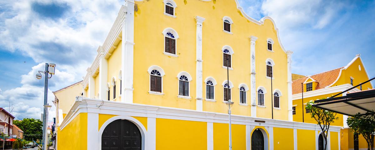
Do: Project the Curaçao synagogue photo at the top of this guide (open the guide on screen and enlarge the picture, or use the congregation's own photos at snoa.com). Say nothing about where it is yet.
Say: "This building is a synagogue, a Jewish house of prayer. Guess where in the world it is." Take four or five guesses. Then: "It is on the island of Curaçao, in the Caribbean Sea, near Venezuela. It was built in 1732, before the United States existed. And the floor inside is covered in sand." Let that land. If a student asks why, give the congregation's own explanation: the sand follows a custom of Dutch synagogues in the 1700s, and sand for the floor was brought from Israel. Guidebooks tell other stories. Stay with the one the synagogue itself gives. Then: "Today we are going to find out how Jewish families ended up living on a Caribbean island, in Africa, in Yemen, and in Poland, and what each family carried with it."
Do: Hand out the world-map handout. Start at dot 8, Curaçao, since the class has just seen it, then travel the map dot by dot. For each one, read the key line together and pull out one concrete example: a food, a language, an instrument. Keep it vivid and specific. Grade 3: read each key line aloud as a class. Grade 4: pairs read the key on their own, then you ask one pair per dot for the detail they remember.
Say: "Families who moved did not pack only clothes. Each card on this sheet shows one tradition that a community carried with it. Each card belongs to one community. Your job is to read the card, find its community in the key under your map, and pack it into the right suitcase."
Do: Pairs, scissors, glue sticks. Hand out What They Carried. Children cut the sheet in half along the dashed line, cut the sixteen cards apart, read each card, find the matching community in the map key, and glue the card into that community's suitcase. The suitcases carry the dot's number and color, not its name, so the key does the work. When both cards are packed, they write the community's name on the suitcase tag. Last, on the map, each child circles the community they would most like to visit. Early finishers: "Pick one card. Tell your partner why a family might carry that across an ocean."
Grade 3: cut the sheets in half ahead of time, or pre-cut the cards if scissors time runs long, and let children copy the community names from the key. Grade 4: children cut and write on their own. If a pair is stuck, point to the colors: the suitcase color matches the dot color on the map.
Answer key: 1 United States (bagel, families from every other dot) · 2 Spain (Ladino, songs in Ladino) · 3 Poland (challah, clarinet) · 4 Morocco (honey pastries, drums and singing) · 5 Ethiopia (Sigd, dabo bread) · 6 Iraq (date cookies, prayer melodies) · 7 Yemen (silver jewelry, the way of saying Hebrew) · 8 Curaçao (sand, the ship from Amsterdam).
Do: Put the photo back up.
Say: "Remember the sand? Families on a Caribbean island. Families in Iraq for 2,500 years. Families in Poland, Yemen, Ethiopia. Different foods, different languages, different music. Look at your map and tell me one way they were all alike." Take three answers. (One people. One shared history. The same holidays. Many homes.) End on the say-back: "One people. Many homes." On the board, for the class to read together: One people, many homes. They carried it with them.